
Kids Autonomy
A Step Forward in Sustainable Mobility
Sustainable mobility is a pressing preoccupation for every large city – Lisbon is no exception.
A group of multi-disciplinary researchers from Portugal has decided to tackle the issue from the point of view of children.
“Many cities are searching for new ways to promote sustainable mobility in general and specifically with children. Promoting public transport, car- and bike-sharing, and free passes for children, are some of the approaches used, many of which depend on mobile device usage and location services” says Cláudia Silva, researcher at the Interactive Technologies Institute / Laboratory of Robotics and Engineering Systems (LARSyS).
Her research project aims to understand how technology can contribute to lessening car dependence by fostering sustainable and independent mobility among children and give caregivers the confidence to allow them to move by themselves. The ultimate goal is the design and creation of a mobile application for that purpose.
Inspired by Human-Computer Interaction (HCI) research advocating for the inclusion of children in the design process and the specific methodology called ‘Participatory Design with Children’, alongside the scientists, the children become co-designers of a mobile application for their own usage. The application will target their needs for mobility and reflect their own perspective of the urban landscape.
Approached as citizens, decision-making beings, responsible for their social context and potential drivers of change, the children are the ‘protagonists’ of the project. Throughout the process, they work and explore notions of space to understand what would be ideal to them, both in terms of technological creation but also in the creation of space (placemaking).
Cartography and Child’s Play
The representation of space, via mapping and cartography, is a communication tool that serves the specific purpose of securing and helping others in their exploration of territory unknown to them. It shows roads and landmarks, geographic features, transport systems, distances, possible dangers and obstacles, resting places… Today, the communication scope of maps in digital format combined with internet technology is even greater. Perhaps a sign of the importance of such tools is the finding that, in the world of digital mobile technology, ‘Google Maps’ is the most used app among consumers.
Countless studies throughout history have been carried out on cartography and mapping, but almost always focused on the adult relationship with space and way-finding systems. Although, since Jean Piaget published theories, we know that children understand landmarks and the environment based on cognitive development stages, the child’s perspective in this context has seldom been explored. One of those rare examples is to be found in the 1970s, in the work of cartographer Barbara Bartz, who dedicated a part of her life to write about and design maps specifically for children.
In many ‘developed’ countries, children’s independent mobility has declined in recent generations. Although the reasons for this are many, a key to start changing this trend might be to understand and observe the child’s relationship with their urban space. Designing and creating technology, possibly even adapting and modifying the urban landscape with regards to these findings might be a step to consider in order to reach more effective mobility-centric city planning.
Towards a More Connected Technology
Most children below the age of 13 already own a mobile phone with associated internet plans. The market of mobile apps is therefore developing such as to target that consumer group, but the world of the navigational apps is still mostly an adult one. Geo-location mobile applications that exist today are mostly for, and designed by, adults. They focus on concerns, such as, the locating of children for surveillance reasons, or on educational purpose like that of geography teaching. These apps fail to take into consideration the interests of children, the particular ways in which they perceive their environment or understand its pictorial representation.
Up to now, the research team has engaged with children from two locations in Portugal in the drawing of cognitive maps of their journeys from home to school. Accompanied questionnaires, written narratives, and personal interviews conducted with the children, completed the studies.
A first study involved 70 students, aged 9 to 12, from the city of Funchal, Madeira (Figures 1 to 8); and a second one, a group of 27 students, 11 to 12 years old, from a private school in Lisbon (Figures 9, 10, 11).
Analysing this material shows how these children perceive their city, what elements in the urban landscape stand out to them (such as landmarks) and how they relate to space as a whole.
From the first field study, in Funchal, 10 types of landmarks were identified while the second, in Lisbon, revealed a set of design recommendations.
Here, we present some/or details of, the cognitive maps drawn by the children, as well as, some of their suggestions and comments.
What They Saw…
Easy to remember striking visual marks such as a street art mural of a whale (Fig. 1 In header ), a large soda advert, a new large store… Infrastructure elements that stand out such as roundabouts (10, 11) and tunnels, bus stop markers, zebra crossings and traffic lights. Along with important visual and conceptual markers such as shops and supermarkets are also churches (3, 4, 5). Other schools than theirs also have a place in their navigation memory. And so do trees (6, 7, 8, … ), gardens, the relative position of the sun and the sea.
It is interesting to see that kids often remember features that stand out of the ordinary, such as the shape of a tree, for example (2, 6, 7, 8, 9). Personal references are also important landmarks, such as a friend’s house or the workplace of someone they know…
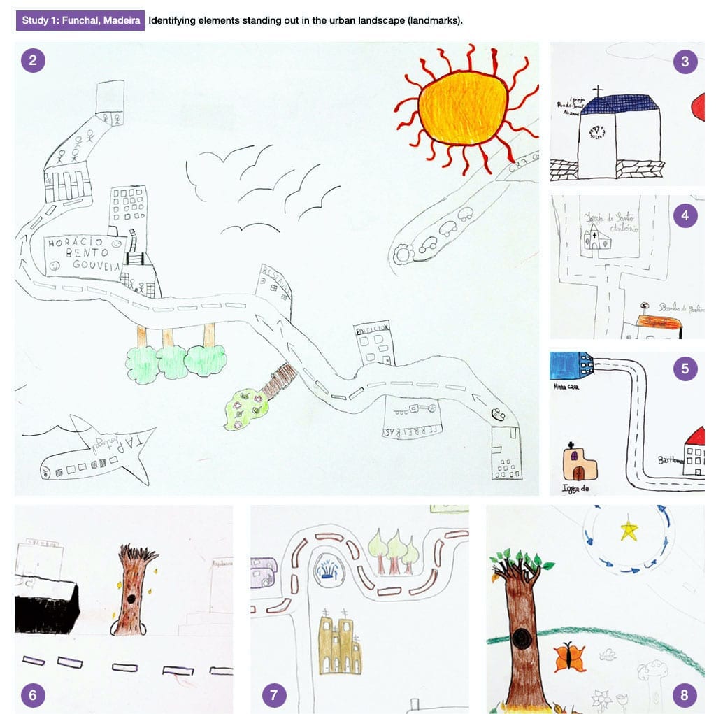
From Study 1: Funchal, Madeira—Identifying elements standing out in the urban landscape (landmarks).
Fig. 1 – Replica of a building’s mural painting (the blue whale). The blue whale mural was an important landmark for the child, and powerful in conveying a sense of place. Drawing by Rita, 12 years old.
Fig.2 – The easiest thing to remember for Pedro in the path from home to school was a tree: “I really like this tree. I find it fun because it has the shape of a pear…” Drawing by Pedro, 10 years old.
Fig. 3, 4, 5 – Churches as landmarks in some of the children’s drawings. — Particularly in Catholic and Christian countries such as Portugal, churches are a culturally important landmark. When responding to the class survey, some children said that they did not know their own street names. However, some children knew the names of the local churches and wrote them down in their drawings alongside their depictions.
Fig. 6, 7, 8 – Trees and gardens as landmarks in children maps.
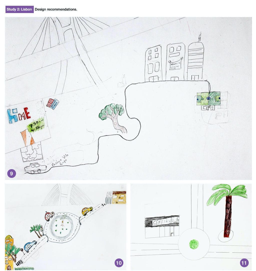
From Study 2: Lisbon — Design recommendations.
Fig. 9. – “If I had this application, I could go to many more places alone without my parents worrying so much.” “My map represents a soccer field, where I train with my team.” Drawing by Rafael.
Fig.10 – “My map represents several palm trees. They represent nature (…) The trees may be a [visual] reference for us, so we cannot get lost.” Drawing by Inês.
Fig. 11 – “The easiest thing to remember was the “Ceifeira Real” [a Café in the neighbourhood where António lives].” Drawing by António
Reaping Benefits Along the Way
Like in all good journeys, every step is important.
Before reaching its destination – with its participatory and multi-disciplinary nature – this project has already impacted many children and parents. The studies are done in the ‘field’, often in the context of an official education system, for example, in the Portuguese or Art class. Drawings, written narratives, questionnaires, storyboards and other interactive experiments will be put into practice. The exchange between the children, scientists, teachers and parents provides a rich educational exercise for all, enhancing awareness in children, awakening their questioning about space, mobility and autonomy.
More about the project at www.childrensworld.m-iti.org
Featured in

Join Planet
REVOLVE today
We strive to communicate sustainability for a better world for the next generations.
Support us by becoming a member of REVOLVE Planet today.
Become a Member