
Guwahati: Where Economic and Ecological Connectivity Collide
In the northeast of India, the city of Guwahati is a regional hub of economic activity facing challenges stemming from ruptures in ecological connectivity. As the city has expanded over the last two decades, development on the floodplain has left Guwahati and its residents vulnerable to catastrophic flooding, and jeopardizing this regional stronghold for India’s Look East/Act East Policy.
A hub of connectivity in the Northeast
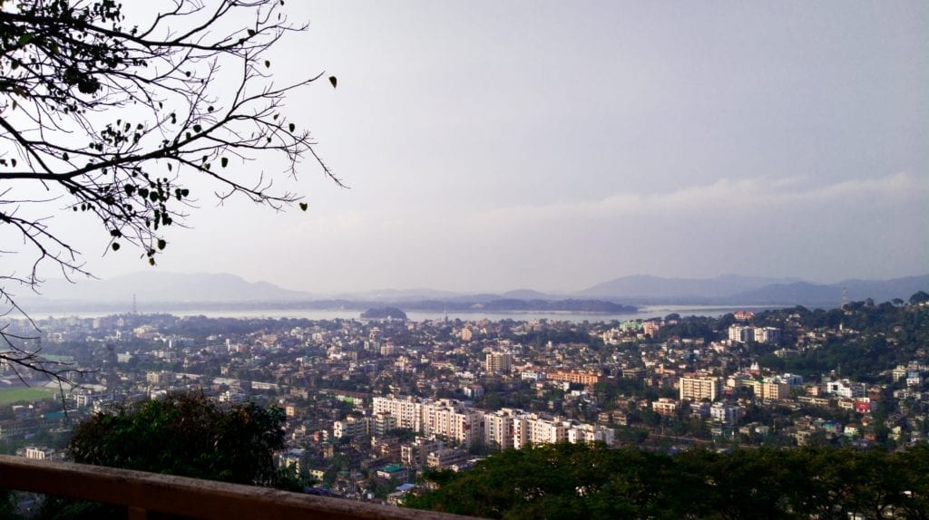
The city of Guwahati in Assam is heralded as the ‘gateway to Northeast India’, as it sits near the mouth of the Siliguri Corridor, known as the Chicken’s Neck, that connects this borderland with mainland India. The city, with over a million inhabitants, is a veritable melting pot of people from different parts of Northeast India. It is home to the region’s only international airport and is an important regional hub of railway connectivity. Over the last two decades, the city has experienced rapid urban growth and development and has been positioned as the regional stronghold for India’s Look East/Act East Policy by New Delhi. The states comprising Northeast India are often described as ‘springboard’ and ‘bridgehead’ for growth, marked by infrastructure project plans that aim to increase connectivity between South Asian and Southeast Asian countries.
Urban flooding in Guwahati
While the catastrophic annual floods along the Brahmaputra in the rural hinterland of Assam have started to receive national and international attention in recent years, the situation in Guwahati has an entirely different flood pulse. Both areas are seeing the impacts of infrastructure development on the nearby floodplains, which reduces the capacity of the landscape to mitigate annual flooding, exacerbated by climate change. However, the sheer scale of the city and its infrastructures means that there is quite simply nowhere for the water to drain, leaving the city and its residents trapped in an urban planning disaster of its own making.
Following heavy downpours during monsoon season, the flooding is such that the streets of Guwahati almost resemble small tributaries of the Brahmaputra, and spectacular images of cars and bikes floating down the streets of Guwahati have been normalized over time. The city’s residents have learned to live with the collective angst associated with this urban planning disaster, which leaves residential areas inundated with floodwaters mixed with garbage, and several lives lost due to electrocution during such episodes of flooding.
Futile Flood Warnings
In August 2020, the city launched its very own city-based urban Flood Early Warning System (FEWS), a web-based tool developed by the Energy and Resources Institute (TERI) in collaboration with the National Disaster Management Authority (NDMA), Assam State Disaster Management Authority (ASDMA) and the India Meteorological Department (IMD), to support urban disaster management and help mitigate the annual rainfall-induced artificial urban floods that render the city’s urban infrastructure dysfunctional.
However, within the city’s borders, a FEWS, while well-intentioned, is futile, as within Guwahati’s cityscape there is absolutely no place for residents to escape the floods reaching their localities and entering their homes. Unlike in rural areas, where FEWS give residents time to gather their belongings and to turn to higher ground, thus reducing somewhat the losses accrued during flood events, within the city, residents are trapped, and losses are inevitable.
A crossroads between economic and ecological connectivity
Guwahati’s position as a regional hub of connectivity stands in stark contrast with the ruptures in the ecological connectivity that have created the conditions for devastating artificial floods. The city’s rapid expansion, accompanied by an infrastructural maze within the city and the highways and railways crisscrossing the peri-urban space, have destroyed critical natural infrastructure, such as wetlands, floodplains, and forests, that are vital to the natural flood management capacity of the landscape. Several wetlands and forests surround Guwahati, the most significant of them being the Ramsar site Deepor Beel. Unfortunately, this wetland has been decimated, i.e. reduced to just one-tenth of its original size, covering just 4 square kilometers today. Over time, a systematic process of ruptures to its natural ecological connectivity has taken place, with railway lines bisecting parts of the Deepor Beel, and several institutions ranging from government facilities, residential colonies and markets, universities, private hotels, small-scale businesses, and brick kilns filling up encroached parts of the wetland. Further, the city’s primary garbage dumping site borders the Deepor Beel, creating further problems for the survival and functioning of the wetland.
Historically, the Deepor Beel has been the natural sponge for the excess rainwater of Guwahati city, balancing significant parts of the rising water levels of some of the important tributaries of the Brahmaputra during the peak monsoon months. However, due to the shrinking size of the wetland, and the disruptions to its connectivity, this function has been severely diminished over the years. The direct impact has been seen in the growing intensity of the rainfall-induced artificial floods in Guwahati, which threaten the city’s reliability as a regional hub of economic activity. To date, this issue has received minimal attention, though it holds important lessons for emerging cities and towns in Northeast India.
Learning from Guwahati
Traveling further inland from Guwahati on the Asian Highway, lies Imphal, the capital of Manipur, another rapidly expanding borderland city in Northeast India. The Loktak Lake, a Ramsar site about 50 kilometers from Imphal, is under stress from anthropogenic activities, including tourism infrastructure projects leading to breaks in ecological connectivity, impacting biota and ecosystem balance. As in the case of Guwahati, the geographical location of Imphal makes it an important part of the vision for India’s Look East/Act East Policy and is projected to grow into a major city in the coming decade. In particular, eco-tourism activities around Loktak Lake are projected to be a major attraction for visitors, and it is critical that lessons from Guwahati and other examples from the region are taken into account.
Similarly, the sacred groves or community-conserved forests in many parts of Northeast India are being impacted upon by road infrastructure and medium to large hydropower projects, leading to the loss of forest cover. These community-conserved forests, particularly in Meghalaya, Nagaland, Arunachal Pradesh and Assam, are critical to the biodiversity of Northeast India. Further, wildlife sanctuaries and reserve forests of the region are increasingly fragmented due to mining activities, leading to an overall shrinking of the ecological spaces and contiguities with negative impacts for the region’s biodiversity. A recent case of an oil well blowout in June 2020 left an Important Bird Area (IBA) called the Maguri Motapung Beel, near the Dibru-Saikhowa National Park, Tinsukia, Assam, devastated, with several commentators calling it ‘catastrophic for the ecosystem’.
Towards multiple types of connectivity
While the conflict between ecological and economic connectivity through the development of physical infrastructure at the expense of the environment, is evident issues facing the region, as highlighted above, there is another level to this conflict; the social. Community and civil society participation levels in decision-making structures and processes related to urban development and city planning, such as in Guwahati, Imphal, Itanagar and Shillong, leave a lot to be desired. Such ruptures in social connectivity have an impact on the core foundation of community participation and environmental democracy in Northeast India, and the consequent marginalization of community-based traditional knowledge systems, which can inform modern natural resource governance policies and its systems.
The way forward requires the harmonization of these three types of connectivity, with physical infrastructure imitating and working with the natural geography of the region and incorporating civil society and traditional knowledge systems in urban planning processes.
The conservation of sacred forests and wetlands by local communities have been time-tested and offer insights into how the Northeast can move forward. An excellent example is the conservation of a high-altitude sacred wetland by local monks, part of the Bhagajang Wetland Complex, which feeds important rivers adjoining Tawang in Arunachal Pradesh. The borderland cities of Northeast India are well-positioned to learn from these lessons and avoid, the unsustainable development trajectory mega-cities in other regions of India, and particularly from examples within the region such as Guwahati.


Join Planet
REVOLVE today
We strive to communicate sustainability for a better world for the next generations.
Support us by becoming a member of REVOLVE Planet today.
Become a Member