
Download Healthy Routes
When the potential of big data is channelled and used properly, the result can be really useful for cities and citizens, particularly for healthier mobility options.
According to the UN, by 2100 the average global temperature will increase 3 degrees generating greater climate instability. These extreme temperatures are affecting agriculture (crops around the world are devastated by hailstorm, droughts and floods), natural areas (forest fires and loss of biodiversity) and cities that, despite the fact that they occupy only 1% of the global surface, they consume 80% of the global energy and they are the main leading emitter of greenhouse gases.
Cities around the world are suffering floods, heat waves and other disasters that are a consequence of extreme temperatures because of climate change and citizens are developing more resilient diseases. According to the World Health Organisation, by 2050 there will be 250,000 additional deaths per year related to climate change problems. Moreover, in 30 years, 70% of the global population will live in urban areas, this means that cities must adapt to embrace all those people and to give them the best quality of life.
All those problems are costing cities more than €8 billion. As reported by experts from the Centre of Atmospheric Sciences of the National Autonomous University of Mexico by the end of this century the percentage of investments that cities would have to make will be equivalent to around 11% of their GDP for the prevention of climate change issues, mainly related to urban heat islands.
For that reason, cities are working to develop strategies to adapt their areas to new global demands: reduce CO2 emissions, create and improve green urban areas, water resources management and waste management among other things. Faced with this situation, Green Urban Data emerged as an intelligent solution for the adaptation to climate change in urban areas focusing on the reduction of temperature effects.
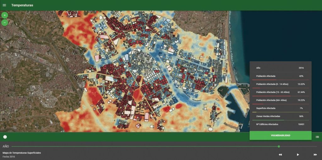
Green Urban Data software monitors and measures environmental data in cities, locating the most vulnerable areas and elaborating recommendations for actions to facilitate the decision-making process of public administrations. The monitoring of a given city is made by mixing remote sensing technology, open source from the administration and analysis of Big Data. Green Urban Data creates a map of the city that allows to visualize thermal information in a simple way to understand the data more easily. By locating vulnerable areas, the software can advise public administrations on where the priority action areas are and can offer recommendations about what would be the best actions to carry out. It also allows to quantify the benefits of the final application of those actions.
The elephant in the room: mobility
The top 3 urban issues are: pollution, energy and mobility – all are interrelated as the increase of any one of them impacts directly on the others; moreover, an increase in any one of them results in higher urban temperatures, aggravating climate change and public health.
In terms of mobility, Hong Kong city is the global leader. They have developed an innovative underground system and most of its population use public transport daily. Hong Kong is not the only one: cities in Europe, like Zurich, Paris, Madrid and Barcelona are working to develop more sustainable ways to move into their respective city.
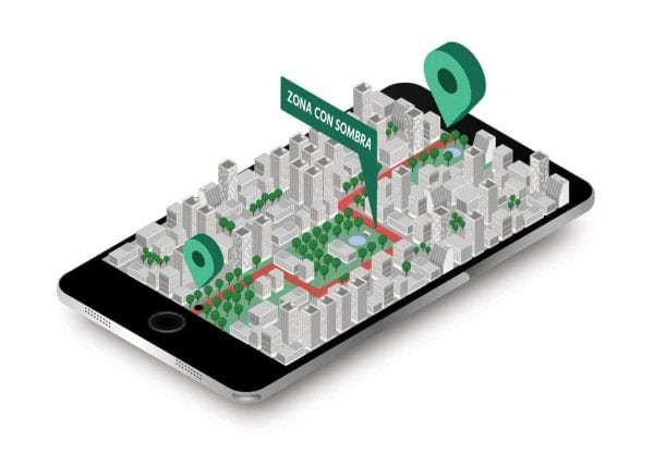
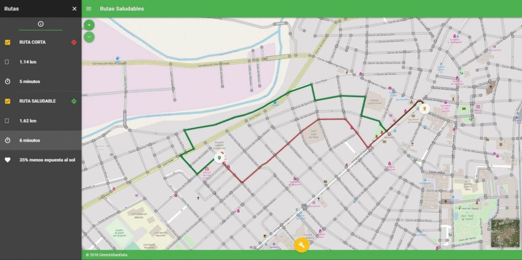
To address this concern, Green Urban Data has created “Healthy Routes” – an app that allows citizens to establish departure and arrival points of their journey, generating a map showing the most “healthy” itinerary compared to the shortest route. Some parameters that can be selected are, for example, a route with a higher percentage of shade, lower levels of allergens, greater accessibility or less noise.
Healthy Routes is a user-friendly app designed for all citizens. Elderly and children, who are more vulnerable to extreme temperatures, can use it to walk through shaded areas, where temperature differences are less dramatic. People suffering from allergies will find the path “cleaner” and, those with physical mobility challenges will find the most accessible route. Healthy Routes is also ideal for runners and sport lovers that look for healthier places for their walking or running routines.
Healthy Routes is a planning tool for public administration. Planning urban strategies can be difficult as there are many things to do and there is not always budget for everything, so it is necessary to prioritize and to carry out the best actions that improve the quality of life for all citizens in all possible ways.
Having a look at the healthiest routes, local governments can take into action for new urban strategies. Some examples include: creating and improving new bike lanes and in this way to promote the use of more sustainable ways of transport by citizens and reduce CO2 emissions.
Healthy Routes selects an itinerary that takes on you on roads with higher percentage of shade, lower levels of allergens, greater accessibility or less noise.
This mobile application can help to project pedestrianization schemes to reduce temperatures in certain areas of the city and to create shaded paths to revitalize social life and the local economy in neighbourhoods. These actions are likewise an attractive claim for tourism, especially in cities with an historic fame of having hot weather, for example Mediterranean cities, like Athens or Valencia, but also others like Las Vegas, México or Bangkok.
Green Urban Data recommendations are framed in the context of advancing urban greenery and sustainable infrastructures. The main strategies are the recovery of parks and green areas with indigenous ‘native’ species, the improvement of irrigation systems and the soil permeability to reduce water consumption.
Urban green areas boost the socialization process, thus helping to increase social and health equity. Greenery improves citizens’ health as green areas reduce stress levels and because of its thermo-regulator impact influences people with heart diseases, chronic illness and lung problems, thus enhancing their general quality of life.
The main goal of Green Urban Data is to help cities to adapt to climate change. Focusing on the effects of temperature this company is helping to improve the quality of life of citizens.
Featured in

Join Planet
REVOLVE today
We strive to communicate sustainability for a better world for the next generations.
Support us by becoming a member of REVOLVE Planet today.
Become a Member